


One Weekend at Heyburn State Park, Idaho
- ChasingBuffaloesandBeyond

- Nov 23, 2021
- 5 min read
Updated: Nov 30, 2021
Idaho! One of our favorite states to visit! With so many beautiful places to pick from it's hard to pick where to go! For this particular weekend, we choose to stay at Heyburn State Park at the Benewah Campground. Heyburn State Park was actually the first state park created in Idaho back in 1908 and it's a true gem! This park is a campers paradise and campers can choose from multiple campgrounds, cabins or cottages and will enjoy the facilities that were built by the CCC (the Civilian Conservation Corps) back in the 1930s. Heyburn State Park includes 5,744 acres as well as 2,332 acres of water, providing for endless opportunities to enjoy the park both by land and water. A total of four bodies of water are available to pick from including Chatcolet Lake, Benewah Lake, Hidden Lakes and the St. Joe River. In addition to the multiple water opportunities, Heyburn State Park is a biker's paradise! The popular 73 mile Trail of the Coeur A'lene that spans the panhandle of Idaho actually runs right thru the park - allowing for easy access to the trail.

TABLE OF CONTENTS
CAMPGROUNDS IN HEYBURN STATE PARK
Located on the east end of the park along Benewah Lake is Benewah Campground where we based ourselves for three days while visiting this region of Idaho. Other campgrounds include Hawley's Landing and Chatcolet. Each campground offers different options - so there should be a site for everyone depending on what you are looking for. For us, we liked the option of being in a site right along the lake and having access to showers so Benewah Campground fit what we were looking for. Here is a quick overview of what each campground in Heyburn State Park offers:
Benewah Lake (39 total sites - both tent and RV sites, showers, public dock, boat launch)
Hawley's Landing (52 sites total - both tent and RV hookup sites, showers, public dock)
Chatcolet (38 tent sites, no RVs, no showers, boat launch)


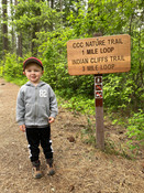
INDIAN CLIFFS TRAIL
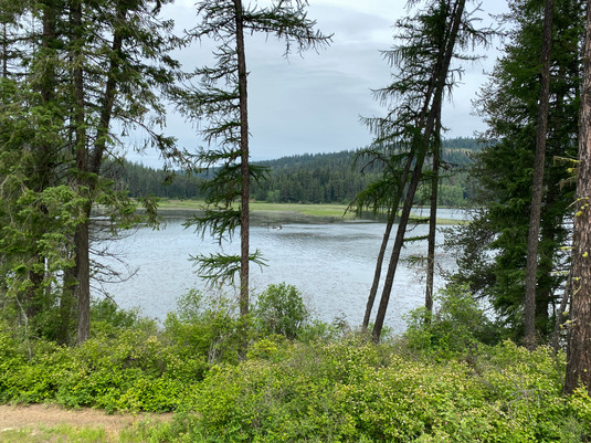
After arriving later in the evening to our campsite the previous night, we were up bright and early the next day, ready for some hiking! To start our exploration of Heyburn State Park, we set off for the 3 mile, 560 feet in elevation, Indian Cliffs Trail. This trail winds up thru the tree line until you pop out along the rocks at the top of the cliff. Once at the top, take in the great views out over the southern end of Lake Coeur d'Alene which is also known as Chatcolet Lake. Looking across the lake to the other side, look close and you will see the railroad lines which are still in use today. For us, this trail was quite memorable as we were hiking with our 3 year old son who was just beginning to hike on his own rather than being carried in the backpack. And he did the entire hike by himself! Way to go buddy!


LAKESHORE LOOP TRAIL
Next on our agenda for the day was to hike the 0.9 mile Lakeshore Loop Trail. The trail begins in the Hawley's Landing Campground and continues to the Plummer Creek Marsh Wildlife Viewing Area. Keep your eyes peeled for wildlife as you walk along the boardwalk - heron, osprey and even moose are known to frequent this area! No luck for us on viewing wildlife - but no worries, the trail itself is very scenic and is worth the quick walk!


KAYAKING CHATCOLET LAKE
To continue exploring Heyburn State Park, we then headed to the Chatcolet Lake Boat Launch to spend some time kayaking! From the boat launch near Chatcolet Campground we set off in our kayak to spend some time out on the lake. For us, we love to travel with an inflatable kayak that makes it easy to bring along when we camp, allowing us to get out on the water with minimal effort. Unfortunately the day had clouded up a bit and the breeze had picked up, so we didn't stay out on the water for too long.

EXPLORING AND FISHING ALONG THE ST. JOE RIVER SCENIC BYWAY
For our second day, we spent the day just outside of Heyburn State Park - along the St. Joe River Scenic Byway. The 106 mile route leaves from St. Maries, Idaho and follows the St. Joe River towards the Idaho/Montana border towards St. Regis, Montana. Along the way enjoy beautiful scenic forest views and a crystal clear river that offers some of the best trout fishing in Idaho.

The St. Joe River is actually the highest- elevation navigable river in the world and the upper portion of the St. Joe is designated as a 'Wild and Scenic' river meaning it is quite popular with fishermen and rafters during certain times of the year. Shortly after leaving the town of St. Maries be on the lookout for Falls Creek Falls - this beautiful little waterfall can be seen from the road, without requiring a hike to see it. Further along, as you travel along the St. Joe River Scenic Byway keep an eye out for the Marble Creek Interpretive Site which offers a couple of informational displays about the logging history of the area. In the early 1900's the town of St. Maries was primarily a logging town and the waters of the St. Joe were an important part of the logging industry as the river was used to move the logs down the river. Moving on, the last little town you will pass thru on this drive before entering into the St. Joe National Forest is the small town of Avery. Choose to either continue all the way to St. Regis, Montana or turn around somewhere beyond the town of Avery before crossing the Idaho border into Montana.


THE TRAIL OF THE COEUR D'ALENES
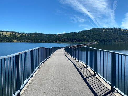
For our last morning at Heyburn State Park, we made sure to spend some time enjoying a portion of the Trail of the Coeur d'Alenes. This 73 mile trail stretches down thru the Idaho panhandle from Mullan to Plummer and is definitely one of the top trails in Idaho. Following along an old railroad line from the Union Pacific Railroad, the paved trail is perfect for bikers, walkers and skaters and provides scenic views from Mullan, to the Coeur d'alene River, along Lake Coeur d'alene and thru beautiful farmlands before ending in Plummer. Twenty developed access points are provided along the trail and one happens to be right in Heyburn State Park near Chatcolet Lake. One of the most scenic parts of the trail is actually located in the park where the Chatcolet Bridge crosses over Chatcolet Lake. As we were visiting with a 3 year old that had just learned to ride a bike, we strolled/biked about a mile or so from the access point along Chatcolet Lake across the bridge and slightly past until our little guy couldn't go any further. Someday we hope to return and spend some more time riding this wonderful trail!


Interested in planning your own trip to Heyburn State Park? Below is our summarized itinerary for you to follow or adjust to your own preferences. ENJOY!
Day 1 - Morning hike - Indian Cliffs Trail (2.6 miles, 560 feet of elevation). Quick 0.9 mile Lakeshore Loop Trail, then afternoon kayaking Chatcolet Lake from Chatcolet Lake Boatlaunch.
Day 2 - Drive the St. Joe Scenic Byway - fish along the way. Other stops include Falls Creek Falls, Marble Creek Interpretive Site, town of Avery.
Day 3 - Trail of the Coeur d’Alenes through Heyburn State Park - walk/bike a small portion of the trail. Park near Chatcolet Lake Boatlaunch to walk portion that crosses the lake.


Comments