


Three Amazing Days in Capitol Reef National Park
- ChasingBuffaloesandBeyond

- Aug 11, 2022
- 14 min read
Located in South Central Utah along a wrinkle in the earth known as the Waterpocket Fold, Capitol Reef National Park is one of Utah's true gems. Filled with colorful rocks, sandstone cliffs, canyons, domes, monoliths, natural arch bridges and some of the most stunning scenery you will find anywhere in Utah. Capitol Reef National Park is named for the white 'capitol' dome formations that resemble the domes you often see on state 'capitol' buildings and 'reef' comes from the term that refers to rocky harsh landscapes that are hard to cross just as a 'reef' on the ocean is a barrier to crossing. The area was first was first designated as Capitol Reef National Monument in 1937 by President Roosevelt and in 1971, it was officially upgraded to Capitol Reef National Park as our nation's 35th National Park. Here is how to spend three amazing days exploring Capitol Reef National Park.

TABLE OF CONTENTS
Day 1:
TORREY, UTAH & THOUSAND LAKES RV PARK
Known as the gateway to Capitol Reef National Park, the small town of Torrey, Utah is located just 8 miles out of Capitol Reef National Park and offers the closest area to find a few amenities such as restaurants, gas, lodging and campgrounds. While Capitol Reef National Park does offer camping within the park at the Fruita Campground (which looked lovely), we choose to stay at the Thousand Lakes RV Park as they offered shower facilities and a pool - which was wonderful since we were tent camping with a toddler and after long busy days of hiking, we loved being able to head back to the campsite for some afternoon swimming! Offering clean facilities and great views towards the colorful rock formations nearby, we loved staying at Thousand Lakes RV Park!


EXPLORE HWY 24 SIGHTS
Two main roads run thru Capitol Reef National Park - Hwy 24 and the Scenic Drive that cuts down south from the Visitor Center. For our first day in the park, we spent the day exploring the sights found along Hwy 24. Traveling this road will give you a good introduction to the beauty and diversity found in Capitol Reef National Park. This 15 mile stretch of road is great for those that only have limited time to see the park. We choose to dedicate an entire day to this stretch of Capitol Reef National Park.

TWIN ROCKS
To begin exploring along Hwy 24, the first sight you will see, at about one mile past the Capitol Reef National Park entrance sign are the easy to find Twin Rocks. A pullout will provide great views of the mushroom like rocks formations.

CHIMNEY ROCK
Continuing on, keep an eye out for the famous Chimney Rock. The chimney looking rock formation stands towering 300 feet above Hwy 24 and is quite easy to spot. Near the rocks, you can find a small parking area for the Chimney Rock Trailhead. This 3.5 mile roundtrip hike is listed as a strenuous hike but is a great place to get out and take in some scenic views of the area. We hiked just a small portion of the trail, maybe a mile total but the little bit we did was wonderful offering great views everywhere!


PANORAMA POINT
Driving west on Hwy 24, take the turnoff road marked for 'Panorama Point & Goosenecks' and follow this gravel road to the first parking lot. From the parking area, follow the quick 0.3 mile trailhead and voila - beautiful views for miles! Panorama Point provides brilliant 360 degree views and is a great place to soak up the beautiful scenery.

GOOSENECK OVERLOOK
Continue following the road that brought you to Panarama Point to the end of the road and you will come to the Gooseneck Overlook and Sunset Point parking lot. Start by following the sign towards Gooseneck Overlook, here another quick walk rewards you with more stunning scenery. Following a quick 600 foot trail (which should take you about 5 minutes), you will come across a view overlooking Sulphur Creek as it winds it's way thru the deep rugged canyon about 800 feet below.


SUNSET POINT
From the same parking lot as Gooseneck Overlook, you will find the trailhead for Sunset Point. This easy trail is less than a mile out and back and follows the rim of the Sulphur Creek Canyon to the top of a red rock ridge where you can enjoy stunning views of Chimney Rock and the other colorful cliffs and rock formations of Capitol Reef. The area is named Sunset Point as it is one of the best places to come and catch a beautiful sunset over the rugged rocky terrain of Capitol Reef National Park.

THE FLUTED WALL
Back on Hwy 24, right along the roadside you will come across The Fluted Wall. This feature provides a great area to view the various layers of rock found in Capitol Reef National Park and see first hand a bit of geological history. Dating back 245 millions year is the red Moenkopi Sandstone found on the bottom layer, the middle gray and purple rock dates back 225 million years and is known as the Chinle Formation and on the top is the Wingate Sandstone which dates back about 200 million years.

THE CASTLE
While Hwy 24 is filled with beautiful and unique rock formations - the The Castle is probably the most iconic formation found in Capitol Reef National Park. The Castle stands towering 6,387 feet tall over Hwy 24 and can also be seen from the Visitor Center. Resembling a castle, this is one rock formation you won't forget!

VISITOR CENTER
Just off Hwy 24, you will find the one Visitor Center in Capitol Reef National Park. Stop in to grab your National Park Passport stamp and a few souvenirs! Our son was also able to get and complete his Junior Ranger book and earned himself a Junior Ranger Badge - he was so excited! Such a fun experience for children and I'm so glad we make this a part of all his National Park experiences!

HISTORIC FRUITA SCHOOLHOUSE
Located in the area known as Fruita, this area was first settled by Mormon settlers and the schoolhouse itself dates back to the 1890s when a school was first established for the local children. Today you can peer inside this historic one room schoolhouse and hear a recording from one of the original teachers at the school. The school was in use until 1941 when it was closed down due to lack of students.

FREMONT PETROGLYPHS
While the Mormon settlers were the first people in recent modern history to settle into the Fruita region within Capitol Reef National Park, the Fremont people actually lived in this area from about 600 to 1200 AD. Today you can see the ancient markings the Fremont people left behind, engraved into some of the stone walls along the Fremont River. Two short boardwalks are found here where you can get an up close view of the petroglyphs.

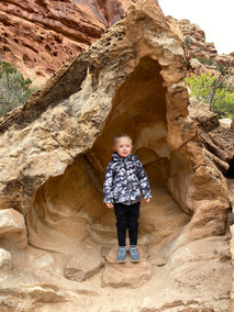
HICKMAN BRIDGE TRAIL
After our numerous stops along Hwy 24, it was time to spend some time enjoying a true hike in Capitol Reef National Park. Hickman Bridge Trail is a 2.5 mile roundtrip trail that is a must do while visiting Capitol Reef National Park. We absolutely loved this hike - starting out along the Fremont River, the trail quickly gains a bit in elevation before leveling back off - all while providing some stunning views of the area. Views of the river, famous domes and unique rock formations as well as lots of fun areas to scramble along the rocks make this a perfect family hike. We enjoyed this hike with our 3 year son - but be aware of the hot Utah sunshine! We hiked this trail late in afternoon when the temperatures were pushing the upper 90's and boy was it hot! Just remember to drink tons of water - and if possible - try and get your hiking done early in the day! Named for Joseph Hickman who worked to protect and preserve Capitol Reef National Park - the beautiful arch known as Hickman Bridge spans 133 feet and stands 125 feet tall - what a sight! This ended up being one of our favorite spots in Capitol Reef National Park!


CAPITOL DOME
After finishing the hike to Hickman Bridge, we continued driving east along Hwy 24 to the park boundary to see our last few sights for the day. Just past the parking lot for Hickman Bridge, keep an eye out for the white rock formations or domes. These domes helped inspire the name of the National Park as the white domes reminded early visitors to the area of the domes found on capitol buildings.

BEHUNIN CABIN
Our last stop of the day to finish our exploration along Hwy 24 was to stop at the Behunin Cabin. Built in 1883 for the Behunin family, this one room house was home to a family of 15. Due to the size of the small home, many of the children actually had to sleep outside in a dugout along the cliffs. Take a walk around the grounds and image life here as a settler - it's pretty amazing to see a building such as this still standing, and it gives quite an appreciation for the early settlers who first moved into this valley.

Day 2:
EXPLORING THE CATHEDRAL VALLEY
For our second day of exploring Capitol Reef National Park - we headed to the remote portion of the park known as the Cathedral Valley district. This northern corner of the park is a remote, rugged landscape that is definitely an adventure you won't soon forget! The unpaved road thru the Cathedral Valley requires a high clearance vehicle and you will also have to fjord a river - yep that's right - you have to drive your vehicle thru a river to reach this stunning part of Capitol Reef National Park. Conditions along the road change based on recent or current weather conditions and it's advised that you check in with the Visitor Center regarding the conditions of the road and the depth of the river you will need to cross. The 58 mile loop through the Cathedral Valley includes numerous overlooks and a few short hikes and will take a full day - so plan accordingly. As the least visited area of Capitol Reef, you will see very few people during your exploration through the Cathedral Valley district - so make sure you well prepared with plenty of food, water and even supplies to dig out your vehicle if you get stuck in the sand - a shovel or even cardboard is highly recommended in the event you do get stuck! For us, we did come across a stuck vehicle and almost got stuck ourselves in the drifting sand that was over a foot deep in some areas! Yep - it was an adventure we won't forget! To read my full blog on spending a day exploring the Cathedral Valley - Click Here.


TIP - Make sure and drive the Cathedral Valley loop in a clockwise direction. This will make the river crossing be at the beginning of your trip - that will you don't drive the entire way only to find out that you can't make it across the river!
Day 3:
CAPITOL REEF SCENIC DRIVE
For our last day exploring Capitol Reef National Park - we focused on visiting the Capitol Reef Scenic Drive and the Waterpocket Fold district located in the southern portion of Capitol Reef National Park. To start off our day we headed to the Capitol Reef Scenic Drive that cuts down south from the Visitor Center. This 7.9 mile paved road will take you thru some of the most scenic views found anywhere in Capitol Reef National Park. Along the Scenic Drive you will find the Fruita Historic District, as well as two dirt spur roads - the Capitol Gorge and Grand Wash Roads - both are a must do and lead to trailheads for further exploration of the area.

FRUITA HISTORIC DISTRICT
Our first stop along the Scenic Drive was in the Fruita Historic District. This valley has been home to people for thousands of years, from the early Fremont people who lived here from about 600 to 1200 AD, to the more recent Mormon settlers that moved into the area around the 1880s.
GIFFORD HOMESTEAD
Arriving to the Gifford Farmhouse and Museum, you are able to take a step back in time and imagine life as it was for the Mormon settlers that first lived here. The house was built in 1908 by Calvin Pendleton and was eventually sold to Dewey Gifford in 1923. The Gifford family then occupied the farm for 41 years until 1969. Today, the 200 acre Gifford Farm is listed on the National Register of Historic Places and includes not only the farmhouse but numerous outbuildings, the large barn and various farming equipment found throughout the farm. The main farmhouse has been restored and houses a small shop where you can purchase reproductions of items that were used by the Mormon settlers of Fruita as well as the famous pies! Try and stop by early in the morning as the pies are quite popular and can sell out by mid-day. We tried both the Mixed Berry and Apple pies and they were delicious!!


FRUITA ORCHARDS
Also found in the Fruita District are the numerous fruit orchards - apples, cherries, peaches, pears, plums, and apricots fill this valley and helped to feed the Mormon settlers that lived here from the 1880s to the 1960s. Today the pies that can be purchased from the Gifford House use the fruit from these orchards. If you happen to visit during the right season, visitors can even spend some time picking fruit from the orchards! We happened to visit late in the fall and just missed being able to pick the late-season apples, but walking thru the orchards was still a fun experience!

GRAND WASH TRAIL
Continuing on along the Scenic Drive, look for the Grand Wash spur road. Follow this 1.2 mile road to the end, where you will find the Grand Wash Trailhead. This 4.4 mile roundtrip hike is a great family hike as it is quite flat the entire way and listed as 'Easy'. The wash here cuts thru the sandstone creating walls up to 500 feet high and in some parts the the walls are less than 15 feet apart offering a wonderful opportunity to experience narrow canyon hiking - but do be aware of the weather - this area is prone to flash flooding and should be avoided if there is a chance of heavy rain. The Grand Wash Trail could actually be turned into a one-way hike if you had access to a shuttle or second vehicle - as the other access point to this trail on out on Hwy 24 - but this was not an option for us with one vehicle. The great thing about this hike though is that it's a wonderful hike to just explore and wander as far as you want, then turn around. We didn't actually hike the full 4.4 miles, we ended up doing probably about a mile into the canyon before turning around. Hike as much or little as you want to - and enjoy stunning views everywhere you look! We had an absolute blast scrambling and climbing along the rock formations as we enjoyed this hike - this was a wonderful kid friendly hike - our 3 year old son had a blast! For those looking for additional hikes in the area - the popular Cassidy Arch Trail can be combined with the Grand Wash Trail for a 7.5 roundtrip hike.


CAPITOL GORGE & PIONEER REGISTER
Travel further south along the Scenic Drive for another seven miles and the paved road will end, from there follow the unpaved 2.5 mile Capitol Gorge spur road and you will come to the parking area for the Capitol Gorge Trail. This is another great family friendly hike that is well worth a stop! The 1 mile Capitol Gorge Trail packs a lot of bang for such a short hike and includes petroglyphs, water filled pockets called Tanks and the historic Pioneer Register where numerous signatures remain from the Mormon settlers who passed thru this area back in the late 1800s/early 1900s. Similar to the Grand Wash, this trail will follow along the main stream bed surrounded by sheer sandstone cliffs and offers a wonderful playground for children to explore and scramble along the rock formations.


WATERPOCKET FOLD DISTRICT
To end our time in Capitol Reef National Park - we headed to explore the less visited, remote southern portion of Capitol Reef called the Waterpocket Fold District. Named for Capitol Reef's defining feature - the Waterpocket Fold runs for nearly 100 miles creating the rugged features, rocky formations, canyons, arches, and cliffs that make up Capitol Reef National Park. While the Scenic Drive cuts straight thru part of the Waterpocket Fold, driving south to the Waterpocket Fold District along the Notom-Bullfrog Road provides outstanding views as it parallels the Waterpocket Fold, offering views along the eastern side of this wrinkle found in the earth.

In preparation of driving this area of Capitol Reef, make sure you have plenty of food, water and gas as help may take hours or days to reach you since this is a less visited portion of the park. Check at the Visitor Center for road conditions - generally this unpaved road is fine for most vehicles, but be aware that rain may make parts of the road un-passable. To drive the full loop - including a stop to hike at Surprise Canyon - plan on allowing 4-6 hours. Here is the recommended route:
From the Capitol Reef Visitor Center head along Highway 24 to the Notom-Bullfrog Road.
Turn right to Notom-Bullfrog Road. Continue driving south past the Burr Trail Road until you see the sign for the Surprise Canyon Trailhead.
After finishing the hike, head back north and turn left on the Burr Trail Road thru the Burr Trail Switchbacks, continue driving west.
At Boulder, head north on Highway 12 to Torrey.
Go east on Hwy 24 back to the Capitol Reef Visitor Center.

SURPRISE CANYON TRAIL
For a fun, somewhat quick hike located in the Waterpocket Fold District of Capitol Reef National Park, Surprise Canyon is a great option! This 2.5 mile trail is another family friendly hike with minimal elevation gain and is easy for all. The trail offers a short section of narrow canyon that cuts thru the Waterpocket Fold. While not narrow enough to be called a slot canyon - walking thru this canyon is still a fun adventure and offers another great location for kids and adults alike to scramble around and enjoy the rock formations found along the trail. The end of the trail is marked by a dryfall where most people turn around as continuing on would require more advanced climbing skills.


BURR TRAIL ROAD
Burr Trail Road connects Capitol Reef National Park to Boulder, Utah and is the MOST stunning road we have ever driven. The road encompasses parts of Grand Staircase-Escalante National Monument and Capitol Reef National Park and is the most scenic drive found anywhere in Utah. As you leave Capitol Reef National Park heading towards Boulder, you will find a steep set of switchbacks that quickly rise 800 feet in only half a mile, providing absolutely outstanding views. It is a true wonder as you think about the early Mormon settlers that first paved the way for this amazing road. Named for John Burr who established the town of Burrville in 1876, he first created these switchbacks in order to move cattle back and forth for summer and winter grazing. Do be aware that part of this road is still unpaved and may become impassable in heavy rains.

LONG CANYON
Leaving the boundaries of Capitol Reef National Park you will cross into Grand Staircase-Escalante National Monument as you drive towards Boulder, Utah. Grand Staircase-Escalante Monument is a vast area spanning almost a million acres and offers a diverse area filled with stunning colorful rock formations, canyons, monoliths, natural bridges and even waterfalls. Following Burr Trail Road, you will cross a small 30 mile portion of Grand Staircase-Escalante which will give you a small sneak peak into this stunning park. Our favorite area along this stretch of road was Long Canyon. The seven mile long canyon features bright red sandstone cliffs steeply rising on both sides of Burr Trail Road. A small slot canyon named Singing Canyon can be found within the walls of Long Canyons and is worth a quick stop while traveling thru this beautiful area. Exiting out of the Grand Staircase-Escalante National Monument you will arrive to Boulder, Utah along Hwy 12. From here you can follow Hwy 12 north back towards Torrey and Capitol Reef National Park - completing the full loop from where we first departed. What a day! Driving thru this amazing portion of Utah was absolutely stunning!

Interested in planning your own trip to Capitol Reef National Park? Below is our summarized itinerary for you to follow or adjust to your own preferences. ENJOY!
Day 1: Explore Hwy 24: Twin Rocks, Chimney Rock, Panorama Point, Goosenecks Overlook, Sunset Point, The Castle, Visitor Center - pick up Junior Ranger Booklet, Historic Fruita School, Fremont Petroglyphs, Hickman Bridge Hike (1.8 miles), Capitol Dome, Behunin Cabin
Day 2: Drive out to Cathedral Valley District: 58 mile scenic drive: Lower South Desert Overlook (0.5 miles roundtrip), Upper South Desert Overlook (0.4 miles roundtrip), Upper Cathedral Valley Overlook (0.2 miles roundtrip), Gypsum Sinkhole, Temple of the Moon, Temple of the Sun (need to double check road conditions before going, will need to cross a river with vehicle, drive the loop clockwise/river first). Plan on 6-8 hours for drive.
Day 3: Capitol Reef Scenic Drive: Fruita Historic District (Gifford Farmhouse - buy a pie here), pick some fruit if in season, continue south on Scenic Drive to Grand Wash Road, Grand Wash Trail (4.4 miles roundtrip - only hike about 1 mile before turning around), Capitol Gorge Spur - hike to Pioneer Register (0.8 miles roundtrip), Drive down to Waterpocket Fold District, Surprise Canyon - 2.0 miles, drive the Burr Trail Road thru the switchbacks as it exits and enters into Grand Staircase-Escalante National Monument. Explore Long Canyon. Continue onto Boulder, then follow Hwy 12 north back towards Torrey.


Comments